Zeroed Out: Why Every State Gets to Start Counting All Over Again
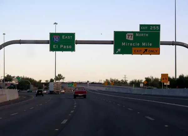
Photo: Patriarca12, CC BY-SA 3.0, via Wikimedia Commons
There's a moment on every long road trip when the numbers go weird. You've been watching mile markers tick up for hours — 238, 239, 240 — and then you cross an unremarkable bridge over a river, and suddenly the sign reads Mile 1. Nothing about the road changed. The asphalt didn't reset. Only the counting did.
Welcome to the strange arithmetic of the American interstate, a system where every state line erases the scoreboard and starts the game over.
The Great Reset at the State Line
Most people drive past mile markers their entire lives without realizing they're reading a language. But the numbers are doing work. On an interstate, the mile marker tells you how far you've traveled within that state — not from the highway's true beginning.
Cross from Pennsylvania into Ohio on I-70 and the count drops back to zero. Cross into Indiana a couple hours later, zero again. It's like every state got handed the same workbook and told to fill in its own page, with no requirement that the pages line up.
The logic is bureaucratic, not poetic: highway maintenance is funded and managed state by state, so each state counts its own stretch. If you're a Ohio DOT crew responding to a crash at mile marker 161, you shouldn't need to know what happened in Pennsylvania to find it. The reset makes the number a local address, not a continental one.
For road-trippers, though, it produces a specific kind of vertigo. You spend 460 miles earning a number, and then — poof — it's gone.
Odd Goes South, Even Goes East
Here's where it gets satisfying. The interstate system, rolled out starting in 1956, runs on a grid logic so clean it feels like it should be taught in school (and occasionally is).
Odd-numbered interstates run north-south. Even-numbered ones run east-west. I-95 hugs the East Coast. I-90 slices across the northern tier from Seattle to Boston. The lower the odd number, the farther west you are — I-5 lives on the Pacific, I-95 on the Atlantic. Same trick with the evens: I-10 skims the Gulf, I-90 scrapes Canada.
And the three-digit spurs? If the first digit is odd — I-195, I-395 — it's typically a spur that connects to the mainline and eventually ends. If it's even — I-295, I-495 — it's usually a loop that circles back around. Beltways, bypasses, the ring roads that let you skip downtown traffic entirely: they're all even-digit children.
Once you see the pattern, you can't unsee it. You can drive into an unfamiliar city, glance at a shield, and know roughly what the road intends to do. It's the closest thing American infrastructure has to a readable source code.
Exit Numbers: Two States, Two Philosophies
For decades, exits were numbered sequentially — Exit 1, Exit 2, Exit 3 — which made the numbers feel like addresses but functioned like a headcount. Build a new interchange between Exit 12 and Exit 13 and you'd get stuck with something like Exit 12A forever, a permanent scar on the map.
That's why most states switched to mile-based exit numbering: the exit number equals the mile marker where it sits. Miss your exit? The sign just told you exactly where you are. It's a two-for-one of information density.
A few holdouts clung to sequential numbering well into the 2000s. Connecticut was famously the last — it didn't convert until 2023, and even then it kept its old numbers alive as reference points on the signs. Vermont switched in 2011. New Hampshire held out until 2021. New England, as a region, treated exit numbers like family heirlooms.
The mile-based system's hidden bonus: you can estimate travel time from the numbers alone. Sixty miles between exits means roughly an hour, give or take construction. The highway is telling you its pace.
Zero Milestones and the Romance of Nothing
The counting obsession goes way back. Before interstates, roads were marked from the nearest city hall or railroad depot, which is why old routes have a tangle of inconsistent numbering. The zero milestone outside the White House — a small granite marker on the Ellipse — was once the ceremonial starting point for measuring distances to destinations across the country. Highway planners in the early 20th century loved the idea of a single national origin point, even if practice never fully cooperated.
There's something almost philosophical about a zero point. Every road trip is a story about distance, and every distance needs a place where the counting begins. The interstate system just decided there would be fifty of them — one per state, quietly rebooting every time you cross a line.
What the Numbers Know
So the next time you're burning across Kansas on I-70 and the mile markers start climbing, take a second to read the tea leaves. The even shield means you're heading east-west. The rising numbers hint at which border you're approaching. The exit number matching the mile marker means somebody, somewhere, designed this so a lost driver could figure out where they were with nothing but the road signs.
Mile 460 in Ohio is a nobody's landmark and a local's whole world. That's the quiet charm of the system: it counts for everyone, but it only makes sense if you know which page of the workbook you're on.
Every number tells a story. On the interstate, it also tells you exactly how far you've got left to drive.